


Page 14 - 展高雄系列展覽專刊-阿蓮田寮特展
P. 14
12    13
                      阿蓮姐與田寮哥的奇異旅程


                       阿蓮姐的大崗山之歌


                       DAGANG  MOUNTAIN


                       大崗山橫跨阿蓮、田寮、燕巢和岡山四區,主要範圍在阿蓮區內,南北長約 4公里,東西寬
                       度不到 2公里,總面積約 750公頃,海拔最高達 312公尺,外觀是從平原突起的一座台地狀的
                       方山。由於地勢高曠又鄰近海岸,可瞭望港灣平原,在日治時期是重要的軍事據點。大崗山
                       的地形西陡東緩,東側石灰岩體較厚,日治時期的軍事洞穴多在東側開洞,西側山下則設機

                       場。二戰後水泥公司在東南側採石,由上而下分梯開採,形成階梯地貌,今已綠化為公園。大
                       崗山西側以觀光、寺廟與果園的利用居多。


                       Dagang Mountain spans Alian, Tianliao, Yanchao, and Gangshan, but the greatest area of it is located in the Alian
                       District. It is 4 kilometers in length and less than 2 kilometers in width, occupying an area of 750 hectares with
                       an elevation of 312 meters above sea level.  e mountain resembles a tableland rising from the plains. Its height
                       and proximity to the sea allows a commanding view of the plains and harbors, so it was used as a military base
                       by the Japanese during their occupation of Taiwan.  e mountain is steep on its West side, but on the East the
                                                                    slope is gentler. The Japanese dug caves on the
                                                                    East side for military use because it is composed of
                                                                    large limestone masses; on the West at the foot of
                                                                    mountain they built an airport. A er the Second
                                                                    World War, concrete companies quarried rocks
                                                                    from the Southeast side beginning at the top and
                                                                    working down over multiple phases. Today the
                                                                    mountainside is terraced from the quarrying, and
                                                                    a park has been built in the area.  e West side of
                                                                    the mountain, with its temples and orchards, is
                                                                    used mostly for sightseeing.


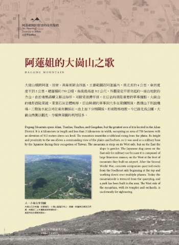
                       大、小崗山空拍圖
                       大崗山位於阿蓮、田寮境內,小崗山座落在岡山、燕巢、阿蓮與田寮的交界
                       處,相鄰的二山均屬隆起珊瑚礁地形。
                       高雄市政府都發局提供。


                                 從台 19甲線望向大崗山
                                 大崗山人文協會提供。

